The Korean Demilitarized Zone (DMZ) is a 2-1/2 mile wide strip of land, without any humans and machines that serve as a buffer between North and South Korea, and is surrounded by landmines, bunkers and crisscrossed by barbed wire. It was established in 1953 after a cease fire agreement that effectively ended three years of bloody conflict that took over 3 million lives during the Korean War. It is the most heavily fortified border in the world, and a peace treaty was never signed, so the two countries are technically still at war. Recently, the tension between the two countries is getting worst and there may be at war anytime due the nuclear conflict.
The tour bus took about 1.5 hours from Seoul to Imjingak, which was the first stop. Imjingak was built in 1972, to console the Koreans from both sides who are unable to return to their home country, friends and families because of the Korea separation into North and South Korea. The South Korea hopes that the unification will happen between the two countries, well looking at the current situation, it’s highly unlikely, sigh. Imjingak is now one of the famous tourist spots for foreigners because it is possible to visit without going through any security check points.
We need to change bus to the designated shuttle bus at the Imjingak parking lot to proceed to the next destination in the DMZ tour. We were given 30 minutes free time before the shuttle bus departing.
Nearby is the Mangbaedan Memorial Altar which used to comfort the 10 million South Korean people separated from their families in North Korea, joint memorial services for parents in North Korea are held at Memorial Altar during the Lunar New Year and Chuseok, Korea's major holidays.

Opposite is the three-storied Imjingak building that are surrounded by several monuments, Unification Park and North Korea Center.


North Korea liquor sold at the souvenir shop

View from the third storey Imjingak building


The one and only train line from South Korea to North Korea.

I was at the right time to capture the train heading to North Korea.

Freedom Bridge at Imjingak was used to allow South Korean and American POWs to cross from North Korea to freedom.


Razor wire fences with banner plea for unification

Unification Pond in the shape of Korea located next to the Freedom Bridge.

Next we onboard the bus to our next destination, the 3rd Tunnel, during the journey, we have to go through the security check-point. A South Korean soldier came onboard and checked our passport before gave us the green light to proceed with the journey.
3rd Tunnel is one of the tunnels dug by the North Korea (though they denied it) under the border between North Korea and South Korea. I t was discovered in 1978 and most probably used for a surprise attack on Seoul. The depth of about 73 m below ground from the diagram of the 3rd Tunnel. The tunnel is 1.6 km long, 1.95 m high and 2.1 m wide. At the lower left of the diagram, South Koreans have blocked the actual Military Demarcation Line in the tunnel with three concrete barricades.

Entrance to the 3rd Tunnel walkway. Visitors have to put on the yellow helmet and then walked down the steep slope. Photograph was not allowed inside the tunnel. There were CCTVs to monitor those trying to snap photos. At the bottom of the tunnel, the ceiling was pretty low, that’s why we need to wear a helmet. It was not a comfortable to walk along all hunched over, but luckily it lasted only about 500 meters. When I came to the end, I could see through a window to the North Korean side. It was locked up tight and covered with barbed wire. There was a "no photography" sign; but I still see visitors secretly snapped few shots. Then I had to walk back up the steep tunnel, which was not an easy task. There were chairs along the way for visitors to rest.

Outside the tunnel vicinity, there was a sculpture showing people pushing together the two halves of a large sphere.

An alternative way to the tunnel using a small train and I believe the tour fee would be slightly expensive if you opt for this option instead of walking down the steep slope of the tunnel.

DMZ Theater where we were given some briefing and footages about North Korea

Statue of South Korean male and female soldier


Then we were off to the Dora observatory, where I could view part of North Korean life from this observation platform, the nearest point to North Korea from South Korea through my bare eye or binoculars. It situated on top of Mount Dora, the observatory looks across the DMZ.

Photography was allowed only behind the yellow line, and there were many soldiers to make sure you didn't cross in front of the yellow line to snap photo else you will be asked to delete the photo on the spot. Consequently, it was pretty much impossible to get a photo of the North Korean side. I basically have to hold my camera at the highest point and blindly shot.

At the North Korea side, you see nothing but only mountain without tree (purposely cut down for easy monitoring to prevent North Korean flea to South Korea), grasses and some trees only. With a binocular, you could see the North Korean propaganda village with multi-storey buildings and apartments with electricity. I was told nobody was living at the village and it’s just to show the South Korean how well-being they are. At the village, there even have the tallest flagpole in the world at 160 m.

Far away is Kaesong Industrial Park where South Korean setup companies at North Korea and employed North Korean as cheap labour, USD57 per month.

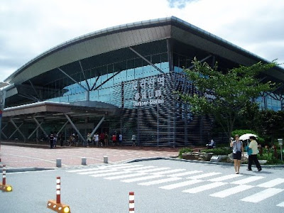
The last stop of the tour was Dorasan Station and it’s the only railroad to North Korea from South Korea. It’s a totally brand new train station that connects between the North and South Korea, but unfortunately it’s currently not in used. Just hope one day South Korean able to go to Pyeongyang (capital of North Korea).

On December 11, 2007, freight trains began traveling north past Dorasan Station into North Korea, taking materials to the Kaesong Industrial Region, and returning with finished goods. It is scheduled to make one 10 mile trip every weekday.
Donation board, contribution made mainly by the South Korean

A view from the parking lot

Outside Dorasan Station

Inside Dorasan Station

I hope you understand what I meant, "Not the last station from the South, But the first station toward the North."

Railroad from South to North Korea

I took a picture with the standing guard

At the counter, I couldn’t find any blank papers, so I stamped my business card with a "commemorative" stamp as a souvenir. Anyone interested, it’s up for sales, haha. Hopefully this station will be used for peaceful commuting between the two countries, but again looking at the current situation, it’s again highly unlikely.
With all the excitement, our bus ride seemed to take longer time to travel back to Seoul. At Seoul, the bus stopped at a ginseng shop for tourist. It’s time to sell stuffs to tourists and for the tour guide to get commissions or freebies. After 30 minutes, the bus dropped us at Seoul Plaza, near City Hall. Coincidently there was a festival held at the City Hall called HOT festival.


No comments:
Post a Comment